렘스테르란트
| 렘스테르란트 | |||
|---|---|---|---|
| — 구기초 자치체 — | |||
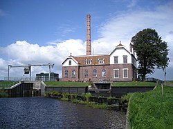
| 에히텐의 펌프장 | |||
| |||
| 좌표: 북위 52도 51부동경 5도 43부□/□북위 52.850도 동경 5.717도□/ | |||
| 국 | 네델란드 | ||
| 주 | 프리스 랜트주 | ||
| 해산 | 2014년 1월 1일[1] | ||
| 면적[2] | |||
| - 계 | 124.34km2 (48mi2) | ||
| - 육지 | 75.93km2 (29.3mi2) | ||
| - 수면 | 48.41km2 (18.7mi2) | ||
| 표고[3] | 0m (0ft) | ||
| 인구(2013년 11월)[4] | |||
| - 계 | 13,544명 | ||
| - 인구밀도 | 178명/km□(461명/mi□) | ||
| 등시대 | 중앙 유럽 표준시(UTC+1) | ||
| - 서머타임 | 중앙 유럽 서머타임(UTC+2) | ||
| 우편번호 | 8508, 8530□8539 | ||
| 시외 국번 | 0514 | ||
렘스테르란트(네델란드어: Lemsterland, 후리 차아어: Lemsterlan)는, 네델란드 북부에 일찌기 존재한 기초 자치체(헤메인테.이하, 본고에서는 편의상 「시」라고 표기한다).2014년에 스카르스테르란(Skarsterlan) 및 하스테르란=스레아트(Gaasterlan-Sleat)의 각 시와 합병해, 새롭고 데・후리세・메이렌시(De Friese Meren)가 되었다.
지구
- 반테하(Bantega)
- 데르후스트라호이젠(Delfstrahuizen)
- 에히텐(Echten)
- 에히테네르브르후(Echtenerbrug)
- 에이스 텔퍼(Eesterga)
- 포레하(Follega)
- 렌멜(Lemmer)
- 오스테르제이(Oosterzee)
- 오스테르제이=브렌(Oosterzee-Buren)
각주
- ^"Gemeentelijke indeling op 1 januari 2014"[Municipal divisions on 1 January 2014] (Dutch). CBS. 2014년 1월 10일 열람.
- ^"Kerncijfers wijken en buurten"[Key figures for neighbourhoods] (Dutch). CBS Statline. CBS (2013년 7월 2일). 2013년 7월 11일 열람.
- ^ "Postcodetool for 8531 ED"(Dutch). Actueel Hoogtebestand Nederland. Het Waterschapshuis. 2013년 9월 21일 열람.
- ^ "Bevolkingsontwikkeling; regio per maand" [Population growth; regions per month] (Dutch). CBS Statline. CBS (2013년 12월 23일). 2014년 1월 20일 열람.
This article is taken from the Japanese Wikipedia 렘스테르란트
This article is distributed by cc-by-sa or GFDL license in accordance with the provisions of Wikipedia.
In addition, Tranpedia is simply not responsible for any show is only by translating the writings of foreign licenses that are compatible with CC-BY-SA license information.


0 개의 댓글:
댓글 쓰기