산=피에르=코라미누
| Saint-Pierre-Colamine | |
|---|---|
 | |
| 행정 | |
| 국 | |
| 지역권(Region) | 오베르뉴 지역권 |
| 현(departement) | 퓨이=드=돔현 |
| 군(arrondissement) | 이소워르군 |
| 오구니(canton) | 르・산시 오구니 |
| INSEE 코드 | 63383 |
| 우편번호 | 63610 |
| 시장(임기) | 미셸・쿠레크[1] (2014년-2020년) |
| 자치체간 연합(fr) | fr:Communautede communes du Massif du Sancy |
| 인구 동태 | |
| 인구 | 238명 (2012년) |
| 인구밀도 | 14명/km□ |
| 지리 | |
| 좌표 | 북위 45도 31부 53초 동경 2도 58부 31초□/□북위 45.5313888889도 동경 2.97527777778도□/ 좌표: 북위 45도 31부 53초 동경 2도 58부 31초□/□북위 45.5313888889도 동경 2.97527777778도□/ |
| 표고 | 평균:730m 최저:706m 최고:1223m |
| 면적 | 17.2 km□ |
 Saint-Pierre-Colamine | |
산=피에르=코라미누(Saint-Pierre-Colamine)는, 프랑스, 오베르뉴 지역권, 퓨이=드=돔현의 컴뮨.
목차
역사
인구통계
| 1962년 | 1968년 | 1975년 | 1982년 | 1990년 | 1999년 | 2006년 | 2012년 |
|---|---|---|---|---|---|---|---|
| 242 | 234 | 210 | 230 | 233 | 224 | 232 | 238 |
사적
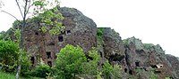
- 죠나 동굴-동굴 주거.원래는 죠나 화산의 분화로부터 생긴, 긴 균열에 따라서 정렬하는 몇개의 뿔꼴로부터 된다.동굴은 모두인의 손으로 파내지고 있다.최초로 동굴을 판 것은 기원 전 400년경의 켈트족 사람들이었다.동굴의 발굴은 중세부터 13 세기까지 계속 되었다.벼랑은 전체 길이 500 m로, 높이는 100 m.동쪽으로 지배계급이, 북측으로 주민과 가축이 살았다.
각주
- ^ Liste des maires 2014, site de la prefecture du Puy-de-Dome (consultele 4 juillet 2014).
- ^ http://cassini.ehess.fr/cassini/fr/html/fiche.php?select_resultat=34105
- ^ http://cassini.ehess.fr/cassini/fr/html/fiche.php?select_resultat=34105
- ^ http://www.statistiques-locales.insee.fr
- ^ http://www.insee.fr
This article is taken from the Japanese Wikipedia 산=피에르=코라미누
This article is distributed by cc-by-sa or GFDL license in accordance with the provisions of Wikipedia.
In addition, Tranpedia is simply not responsible for any show is only by translating the writings of foreign licenses that are compatible with CC-BY-SA license information.
0 개의 댓글:
댓글 쓰기