크루카레현
크루카레현 | |
|---|---|
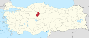 크루카레현의 위치 | |
| 개요 | |
| 지방: | 중앙 아나트리아 지방 |
| 현도: | 크루카레 |
| 현 번호: | 71 |
| 면적: | 4,385 (km2) |
| 인구: | 389,843 2007 |
| 자치체수: | 9 |
 크루카레현의 자치체 | |
| 시외 국번: | 0318 |
| 공식 사이트: | |
크루카레(터키어:Kirikkale il)는 터키 중앙부는 중앙 아나트리아 지방의 현.현도는 크루카레.북쪽에서 체크루, 쵸룸, 요즈가트, 크루시힐, Ankara의 각 현과 접하고 있다.또, 터키 중앙부, 키질강근교에 위치하고 있다.
Ankara에서 동쪽으로 흑해 지방까지 성장하는 고속도로의 교차점으로서 알려져 Ankara-조개 경매간의 철도도 달리고 있다.
이 현 근교의 마을은 주로 철의 광산물 있어 철합금과 기계를 전문적으로 생산했다.이 때문에 1950년대에는 크루카레는 터키 최고 속도급의 인구를 늘어나를 기록했다.1960년대에 들어오면 과학 공장이 더해졌다.크루카레는 산업의 중심으로서 터키 제일의 속도로 성장하고 있다.
하위 자치체
- Bahsili
- Baliseyh
- Celebi
- Delice
- Karakecili
- Keskin
- 크루카레(Kirikkale)
- Sulakyurt
- Yahsihan
This article is taken from the Japanese Wikipedia 크루카레현
This article is distributed by cc-by-sa or GFDL license in accordance with the provisions of Wikipedia.
In addition, Tranpedia is simply not responsible for any show is only by translating the writings of foreign licenses that are compatible with CC-BY-SA license information.
0 개의 댓글:
댓글 쓰기