타와우
| 타와우 Tawau | |||
|---|---|---|---|
 | |||
| |||
| 위치 | |||
 | |||
| 좌표 : 북위 4도 17부 53초 동경 117도 52부 59초□/□북위 4.29806도 동경 117.88306도□/ | |||
| 행정 | |||
| 국 | |||
| 주 | |||
| 시 | 타와우 | ||
| 지리 | |||
| 면적 | |||
| 시역 | 6,125 km2 (2,365 mi2) | ||
| 인구 | |||
| 인구 | (2010년 현재) | ||
| 시역 | 113,809명 | ||
| 인구밀도 | 60.54명/km2 | ||
| 그 외 | |||
| 등시대 | 말레이시아 표준시(MST) (UTC+8) | ||
| 공식 웹 사이트: mpt.sabah.gov.my | |||
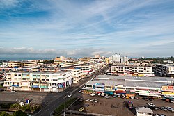
타와우(Tawau)는 말레이시아・사바주에 있는 도시에서, 코타키나발, 산다칸에 뒤잇는 사바주에서 3번째에 큰 도시이다.
목차
지리
역사
1890년대, 타와우의 인구는 보르네오 주변의 섬등에서 온 약 200명이었다.그들은 타와우라마마을에 정주해, 어업이나 벼농사 농가가 되어, 네델란드와 무역을 실시했다.
교통
자매 도시
외부 링크
This article is taken from the Japanese Wikipedia 타와우
This article is distributed by cc-by-sa or GFDL license in accordance with the provisions of Wikipedia.
In addition, Tranpedia is simply not responsible for any show is only by translating the writings of foreign licenses that are compatible with CC-BY-SA license information.

0 개의 댓글:
댓글 쓰기