그아르드(이탈리아)
| 그아르드 Gualdo | |
|---|---|
| 행정 | |
| 국 | |
| 주 | |
| 현 | |
| CAP(우편번호) | 62020 |
| 시외 국번 | 0733 |
| ISTAT 코드 | 043021 |
| 식별 코드 | E228 |
| 분리 취락 | |
| 인접 자치 단체 | #인접 자치 단체 참조 |
| 인구 | |
| 인구 | 827 [1]명(2015-01-01) |
| 인구밀도 | 37.4 사람/km2 |
| 문화 | |
| 수호 성인 | |
| 경축일 | |
| 지리 | |
| 좌표 | 북위 42도 53부 0초 동경 13도 10부 0초□/□북위 42.88333도 동경 13.16667도□/ 좌표: 북위 42도 53부 0초 동경 13도 10부 0초□/□북위 42.88333도 동경 13.16667도□/ |
| 표고 | 652 (276 - 658) [2] m |
| 면적 | 22.11 [3] km2 |
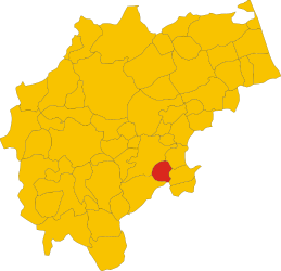 마체라타현에 있어서의 자치 단체의 영역 | |

그아르드(이탈리아어: Gualdo)는, 이탈리아 공화국 말케주 마체라타현에 있는, 인구 약 830명의 기초 자치체(자치 단체).
목차
지리
각주
- ^국립 통계 연구소(ISTAT). "Total Resident Population on 1 st January 2015 by sex and marital status"(영어). 2016년 5월 5일 열람.
- ^국립 통계 연구소(ISTAT). "Tavola: Popolazione residente - Macerata (dettaglio loc. abitate) - Censimento 2001."(이탈리아어). 2016년 5월 5일 열람.
- ^국립 통계 연구소(ISTAT). "Tavola: Superficie territoriale (Kmq) - Macerata (dettaglio comunale) - Censimento 2001."(이탈리아어). 2016년 5월 5일 열람.
- ^ "지도상에서 2 지점의 방위・방위, 거리를 조사한다". 2016년 5월 5일 열람.
외부 링크
This article is taken from the Japanese Wikipedia 그아르드(이탈리아)
This article is distributed by cc-by-sa or GFDL license in accordance with the provisions of Wikipedia.
In addition, Tranpedia is simply not responsible for any show is only by translating the writings of foreign licenses that are compatible with CC-BY-SA license information.
0 개의 댓글:
댓글 쓰기